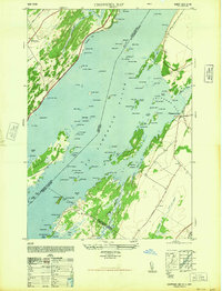
1948 Map of Chippewa Bay
USGS Topo · Published 1948About this map
St Lawrence River island life and international navigation are the primary focus of this late 1940s survey. The map details the complex shoreline and archipelago near Chippewa Bay, where numerous named islands like Dark Island, Cedar Island State Park, and Middle Island are scattered across the water. On the Canadian side, the Canadian Pacific railroad runs parallel to King's Highway No 2, serving settlements like Mallorytown. This era of river history is marked by the active presence of navigation aids, including the Sister Island Lighthouse, Third Brother Lighthouse, and Bridge Island Lighthouse. On the New York shore, rural development is anchored by School No 6 and the recreational grounds of Kring Point State Park. The map also captures the intricate marshlands surrounding Crooked Creek and Goose Bay, providing a clear record of the river's ecological and human geography before mid-century modernization.
Find a feature on this map
117 named features on this map. Tap any name to fly to it.
Don’t see what you’re looking for? This feature index may not catch every label — zoom into the map to look around manually.
Map Details
Editions of this 1948 Chippewa Bay Map
2 editions found
Other maps of this area

1903 · Alexandria Bay
USGS Topo · 1:62,500

1906 · Brier Hill
USGS Topo · 1:62,500

1912 · Hammond
USGS Topo · 1:62,500

1942 · Morristown
USGS Topo · 1:24,000

1943 · Morristown
USGS Topo · 1:31,680

1943 · Redwood
USGS Topo · 1:31,680

1943 · Alexandria Bay
USGS Topo · 1:31,680

1944 · Hammond
USGS Topo · 1:62,500

1948 · Chippewa Bay
USGS Topo · 1:24,000

1948 · Alexandria Bay
USGS Topo · 1:62,500