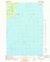
1985 Map of Chippewa Point
USGS Topo · Published 1985About this map
Big Bay De Noc dominates this shoreline survey, where the terrestrial landscape of Delta County meets the expansive waters of Lake Michigan. The interior is defined by the Hiawatha National Forest, a managed woodland that shelters smaller water bodies like Granskog Lake and the inland Indian Town Lake. Along the coast, the land tapers into the prominent Chippewa Point, which serves as a natural transition between the main bay and Green Bay to the south. The drainage patterns of the peninsula are visible through the short reach of Granskog Cr, while Round Island sits isolated to the northeast. This 1980s-era data reflects a landscape primarily shaped by conservation and the natural shoreline, showing no major residential development but preserving the essential geography of this Upper Peninsula coastal reach.
Find a feature on this map
13 named features on this map. Tap any name to fly to it.
Don’t see what you’re looking for? This feature index may not catch every label — zoom into the map to look around manually.
Map Details
Editions of this 1985 Chippewa Point Map
This is the sole edition of this map. No revisions or reprints were ever made.
Other maps of this area

1932 · Burnt Bluff SW
USGS Topo · 1:31,680

1932 · Burnt Bluff NW
USGS Topo · 1:31,680

1932 · Rapid River SE
USGS Topo · 1:31,680

1932 · Rapid River SW
USGS Topo · 1:31,680

1954 · Escanaba
USGS Topo · 1:250,000

1957 · Escanaba
USGS Topo · 1:250,000

1958 · Escanaba
USGS Topo · 1:250,000

1958 · Garden
USGS Topo · 1:62,500

1958 · Peninsula Point
USGS Topo · 1:62,500

1958 · Fairport
USGS Topo · 1:62,500