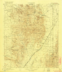
1919 Map of Chiricahua
USGS Topo · Published 1919About this map
Coronado National Forest dominates this topographic survey, revealing the remote ranching and mining landscape of Cochise County during the late 1910s. The map documents numerous family homesteads and livestock operations, such as Hunsaker Ranch, Cox Ranch, and Staffords Ranch, scattered across the basin and range terrain. These small outposts were supported by a network of rural schoolhouses, including the Wilgus School and Hunt Canyon School, which served the isolated communities of the Chiricahua Mountains.
Find a feature on this map
118 named features on this map. Tap any name to fly to it.
Don’t see what you’re looking for? This feature index may not catch every label — zoom into the map to look around manually.
Map Details
Editions of this 1919 Chiricahua Map
3 editions found

Other maps of this area

1914 · Douglas
USGS Topo · 1:62,500

1916 · Pearce
USGS Topo · 1:125,000

1916 · Douglas
USGS Topo · 1:125,000

1917 · San Simon
USGS Topo · 1:125,000

1917 · Chiricahua
USGS Topo · 1:125,000

1918 · Cienega Springs
USGS Topo · 1:62,500

1918 · Animas Peak
USGS Topo · 1:62,500

1918 · Pratt
USGS Topo · 1:62,500

1919 · Pratt
USGS Topo · 1:62,500

1919 · Douglas
USGS Topo · 1:125,000