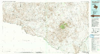
1985 Map of Chisos Mountains
USGS Topo · Published 1993About this map
The Chisos Mountains rise as a high-altitude island within the vast arid reaches of Big Bend National Park, marking a dramatic shift in the West Texas landscape. This mid-1980s compilation shows the intricate topography of the high peaks, including Emory Peak, Casa Grande, and Toll Mountain, while tracing the winding course of the Rio Grande (also labeled Rio Bravo) as it carves through Mesa de Anguila. The map captures a moment when mercury mining history was still visible at the Mariscal Mine and the mercury-mining settlements of Terlingua and Study Butte were evolving into the regional hubs they are today.
Find a feature on this map
122 named features on this map. Tap any name to fly to it.
Don’t see what you’re looking for? This feature index may not catch every label — zoom into the map to look around manually.
Map Details
Editions of this 1985 Chisos Mountains Map
3 editions found

Other maps of this area

1896 · Polvo
USGS Topo · 1:125,000

1896 · Shafter
USGS Topo · 1:125,000

1903 · Chisos Mountains
USGS Topo · 1:125,000

1903 · Terlingua
USGS Topo · 1:125,000

1904 · Terlingua
USGS Topo · 1:125,000

1905 · Chisos Mountains
USGS Topo · 1:125,000

1917 · Agua Fria
USGS Topo · 1:62,500

1917 · Tascotal Mesa
USGS Topo · 1:62,500

1917 · Bone Spring
USGS Topo · 1:62,500

1918 · Bone Spring
USGS Topo · 1:125,000