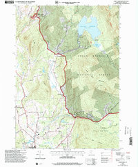
1997 Map of Chittenden
USGS Topo · Published 2000About this map
The Chittenden Reservoir dominates the landscape north of Mendon, acting as a central catchment for numerous mountain streams like Furnace Brook and Hewitt Brook. This late-twentieth-century revision illustrates the rural infrastructure of central Vermont, where small settlements such as Holden (North Chittenden) and East Pittsford are connected by a network of winding mountain roads. The presence of the Pittsford National Fish Hatchery near the northern boundary and the Rutland City Reservoir further south highlights the area's significance for regional resource management.
Find a feature on this map
54 named features on this map. Tap any name to fly to it.
Don’t see what you’re looking for? This feature index may not catch every label — zoom into the map to look around manually.
Map Details
Editions of this 1997 Chittenden Map
This is the sole edition of this map. No revisions or reprints were ever made.
Other maps of this area

1891 · Rutland
USGS Topo · 1:62,500

1893 · Rutland
USGS Topo · 1:62,500

1895 · Castleton
USGS Topo · 1:62,500

1897 · Castleton
USGS Topo · 1:62,500

1902 · Brandon
USGS Topo · 1:62,500

1904 · Brandon
USGS Topo · 1:62,500

1915 · Rochester
USGS Topo · 1:62,500

1917 · Rochester
USGS Topo · 1:62,500

1920 · Brandon
USGS Topo · 1:62,500

1944 · Proctor
USGS Topo · 1:31,680