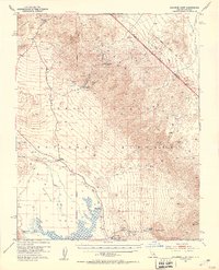
1952 Map of Chloride Cliff
USGS Topo · Published 1953About this map
Death Valley National Monument reveals a stark landscape of extreme elevations and early desert industry in this mid-century survey. The terrain is anchored by the Chloride Cliff area, where historical mining operations are clearly marked, including the Chloride City settlement and the Keane Wonder Mine. The presence of the Keane Wonder Mill (Aband) reflects the boom-and-bust cycle of extraction that defined this region's early 20th-century development.
Find a feature on this map
42 named features on this map. Tap any name to fly to it.
Don’t see what you’re looking for? This feature index may not catch every label — zoom into the map to look around manually.
Map Details
Editions of this 1952 Chloride Cliff Map
4 editions found
Other maps of this area

1908 · Furnace Creek
USGS Topo · 1:250,000

1908 · Ballarat
USGS Topo · 1:250,000

1910 · Furnace Creek
USGS Topo · 1:250,000

1913 · Ballarat
USGS Topo · 1:250,000

1942 · Bullfrog
USGS Topo · 1:125,000

1948 · Death Valley
USGS Topo · 1:250,000

1952 · Chloride Cliff
USGS Topo · 1:50,000

1952 · Stovepipe Wells
USGS Topo · 1:62,500

1952 · Furnace Creek
USGS Topo · 1:62,500

1952 · Ryan
USGS Topo · 1:62,500