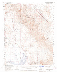
1952 Map of Chloride Cliff
USGS Topo · Published 1967About this map
Chloride City and the surrounding heights of the Funeral Mountains dominate this mid-century portrait of a stark desert landscape. This map captures the transition of the region from a mining frontier to a protected monument, shown through the presence of both the Keane Wonder Mill (Aband) and the National Park Service Hdqrs. Near the center of the sheet, the Chloride Cliff rises above the basin, while the Jean Lemoigne Grave stands as a solitary marker of local history on the floor of Death Valley.
Find a feature on this map
38 named features on this map. Tap any name to fly to it.
Don’t see what you’re looking for? This feature index may not catch every label — zoom into the map to look around manually.
Map Details
Editions of this 1952 Chloride Cliff Map
4 editions found
Other maps of this area

1908 · Furnace Creek
USGS Topo · 1:250,000

1908 · Ballarat
USGS Topo · 1:250,000

1910 · Furnace Creek
USGS Topo · 1:250,000

1913 · Ballarat
USGS Topo · 1:250,000

1942 · Bullfrog
USGS Topo · 1:125,000

1948 · Death Valley
USGS Topo · 1:250,000

1952 · Chloride Cliff
USGS Topo · 1:50,000

1952 · Stovepipe Wells
USGS Topo · 1:62,500

1952 · Furnace Creek
USGS Topo · 1:62,500

1952 · Ryan
USGS Topo · 1:62,500