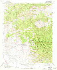
1968 Map of Chloride
USGS Topo · Published 1971About this map
The silver and lead mining town of Chloride serves as the focal point of this 1968 survey, situated at the base of the Cerbat Mountains. The map reveals an incredible density of hard-rock mining activity concentrated along the mountain front, where dozens of named operations such as the Tennessee Mine, Elkhart Mine, and Silver Age Mine follow the mineralization of the range. The proximity of the town to these workings illustrates the classic late-19th-century mining camp layout that persisted into the mid-20th century, even as the scale of operations shifted.
Find a feature on this map
70 named features on this map. Tap any name to fly to it.
Don’t see what you’re looking for? This feature index may not catch every label — zoom into the map to look around manually.
Map Details
Editions of this 1968 Chloride Map
2 editions found
Other maps of this area

1886 · Camp Mohave
USGS Topo · 1:250,000

1892 · Camp Mohave
USGS Topo · 1:250,000

1939 · Chloride
USGS Topo · 1:48,000

1942 · Camp Mohave
USGS Topo · 1:250,000

1944 · Chloride
USGS Topo · 1:62,500

1947 · Kingman
USGS Topo · 1:250,000

1948 · Kingman
USGS Topo · 1:250,000

1954 · Kingman
USGS Topo · 1:250,000

1955 · Kingman
USGS Topo · 1:250,000

1958 · Kingman
USGS Topo · 1:250,000