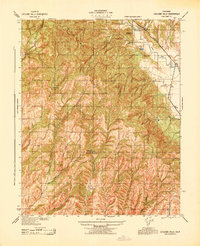
1943 Map of Cholame Hills
USGS Topo · Published 1943About this map
The Cholame Hills define this interior landscape of central California during the early 1940s, marked by a sparse network of ranching homesteads and seasonal camps. Family names are etched into the terrain, identifying holdings such as Hillman Ranch, Harlan Ranch, and smaller sites like Van Dollen and G Huston. The Monterey Co San Luis Obispo Co boundary line cuts through the southern reaches of this territory, where a series of deep canyons, including Hog Canyon, Willow Springs Canyon, and Mad Canyon, dictate the movement of travelers and water.
Find a feature on this map
34 named features on this map. Tap any name to fly to it.
Don’t see what you’re looking for? This feature index may not catch every label — zoom into the map to look around manually.
Map Details
Editions of this 1943 Cholame Hills Map
This is the sole edition of this map. No revisions or reprints were ever made.
Other maps of this area

1914 · Cholame
USGS Topo · 1:125,000

1915 · Cholame
USGS Topo · 1:125,000

1917 · Cholame
USGS Topo · 1:125,000

1919 · San Miguel
USGS Topo · 1:62,500

1919 · Paso Robles
USGS Topo · 1:62,500

1934 · The Dark Hole
USGS Topo · 1:31,680
1937 · The Dark Hole
USGS Topo · 1:31,680

1942 · Parkfield
USGS Topo · 1:24,000

1943 · Shandon
USGS Topo · 1:31,680

1943 · Paso Robles
USGS Topo · 1:62,500