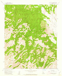
1961 Map of Cholame Hills
USGS Topo · Published 1962About this map
Cholame Hills and the winding Cholame Valley define this mid-century landscape along the boundary of Monterey and San Luis Obispo Counties. The terrain is characterized by a dense network of seasonal drainages and numerous water sources essential for livestock and local camps, including Todds Spring, Willow Spring, and Square Corral Spring. The eastern edge of the map shows the flatlands of the valley where Cholame Creek flows near Covington Lake, providing a sharp contrast to the dissected ridges to the west.
Find a feature on this map
27 named features on this map. Tap any name to fly to it.
Don’t see what you’re looking for? This feature index may not catch every label — zoom into the map to look around manually.
Map Details
Editions of this 1961 Cholame Hills Map
3 editions found

Other maps of this area

1914 · Cholame
USGS Topo · 1:125,000

1915 · Cholame
USGS Topo · 1:125,000

1917 · Cholame
USGS Topo · 1:125,000

1919 · San Miguel
USGS Topo · 1:62,500

1919 · Paso Robles
USGS Topo · 1:62,500

1934 · The Dark Hole
USGS Topo · 1:31,680
1937 · The Dark Hole
USGS Topo · 1:31,680

1942 · Parkfield
USGS Topo · 1:24,000

1943 · Shandon
USGS Topo · 1:31,680

1943 · Paso Robles
USGS Topo · 1:62,500