1898 Map of Choptank
USGS Topo · Published 1902About this map
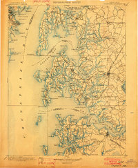
Annapolis and its vital maritime approaches define the western edge of this coastal survey, where the Severn River and South River meet the Chesapeake Bay. The map captures a detailed snapshot of late 19th-century waterborne commerce and travel, anchored by the Annapolis & Baltimore Short Line R.R. and the Annapolis & Elk Ridge R.R. serving the state capital. Eastward across the bay, the complex geography of Kent Island and the Eastern Shore reveals a network of landings and ferries essential to local life, including Browns Ldg Ferry and Foreman Landing. Small settlements like Dominion, Winchester, and Wye Mills are connected by a landscape of necks and points, such as Bats Neck and Tilghman Pt.. Safety for bay navigators is marked by the Bloody Pt. Bar Light, signaling the transition into Eastern Bay.
Find a feature on this map
242 named features on this map. Tap any name to fly to it.
Don’t see what you’re looking for? This feature index may not catch every label — zoom into the map to look around manually.
Map Details
Editions of this 1898 Choptank Map
2 editions found

Other maps of this area

1892 · Leonardtown
USGS Topo · 1:62,500

1892 · Drum Point
USGS Topo · 1:62,500

1892 · Prince Frederick
USGS Topo · 1:62,500

1892 · Owensville
USGS Topo · 1:62,500

1892 · Annapolis
USGS Topo · 1:62,500

1893 · Sharps Island
USGS Topo · 1:62,500

1893 · North Point
USGS Topo · 1:62,500

1894 · Relay
USGS Topo · 1:62,500

1895 · Prince Frederick
USGS Topo · 1:62,500

1895 · Leonardtown
USGS Topo · 1:62,500