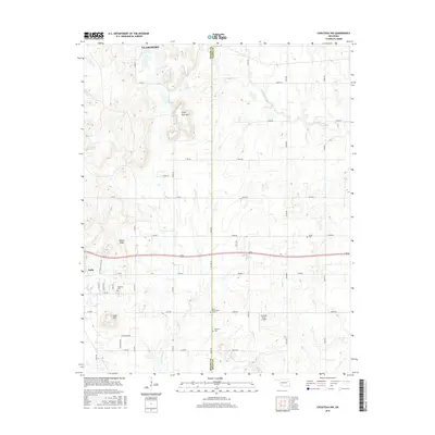
2016 Map of Chouteau NW
USGS Topo · Published 2016About this map
Inola Hill and Scaly Bark Mtn dominate the landscape along the Rogers and Mayes county line, marking a transition from the lower creek beds to higher ridge elevations. This area, surveyed in 2016, preserves the locations of several distinct community burial grounds, including the Amish Cem, Eden Mennonite Cem, and Brethren Cem. These sites, along with the Highland Cem near Inola, offer significant value for genealogists tracing the religious and cultural heritage of this region. The map details a complex network of rural section roads and drainage patterns for Chouteau Creek and Bull Creek, while the private Buzzards Roost Airport serves as a modern landmark. The terrain character is further defined by elevations like Timber Ridge and the southern edge of Claremore, providing a clear view of the rural settlement patterns between the major waterways.
Find a feature on this map
47 named features on this map. Tap any name to fly to it.
Don’t see what you’re looking for? This feature index may not catch every label — zoom into the map to look around manually.
Map Details
Editions of this 2016 Chouteau NW Map
This is the sole edition of this map. No revisions or reprints were ever made.
Other maps of this area

1896 · Pryor
USGS Topo · 1:125,000

1901 · Claremore
USGS Topo · 1:125,000

1901 · Pryor
USGS Topo · 1:125,000

1914 · Claremore
USGS Topo · 1:125,000

1916 · Claremore
USGS Topo · 1:125,000

1954 · Tulsa
USGS Topo · 1:250,000

1958 · Tulsa
USGS Topo · 1:250,000

1963 · Tulsa
USGS Topo · 1:250,000
1963 · Neodesha
USGS Topo · 1:24,000
1963 · Claremore
USGS Topo · 1:24,000