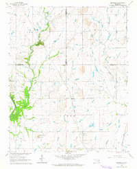
1963 Map of Neodesha
USGS Topo · Published 1964About this map
Bull Creek carves a prominent path through this 1963 landscape where the borders of Wagoner, Rogers, and Mayes counties converge. The small settlement of Neodesha sits centrally, anchored by a rural transport network that includes the Missouri Pacific and Missouri-Kansas-Texas railroads. This era reflects the mid-century transition of the Oklahoma countryside, where traditional landmarks like Lone Star Ch and Willow Cem remained vital community anchors even as land use shifted. Significant geological and industrial features, such as the Osage Mound and a local Gravel Pit, provide evidence of the region's physical character and early resource extraction. The drainage patterns of Flat Rock Creek and Billy Creek define the local topography, illustrating the natural water systems that dictated the placement of early homesteads and rail lines.
Find a feature on this map
16 named features on this map. Tap any name to fly to it.
Don’t see what you’re looking for? This feature index may not catch every label — zoom into the map to look around manually.
Map Details
Editions of this 1963 Neodesha Map
2 editions found
Other maps of this area

1896 · Okmulgee
USGS Topo · 1:125,000

1896 · Pryor
USGS Topo · 1:125,000

1900 · Okmulgee
USGS Topo · 1:125,000

1901 · Muscogee
USGS Topo · 1:125,000

1901 · Claremore
USGS Topo · 1:125,000

1901 · Pryor
USGS Topo · 1:125,000

1905 · Muscogee
USGS Topo · 1:125,000

1914 · Claremore
USGS Topo · 1:125,000

1916 · Claremore
USGS Topo · 1:125,000

1946 · Fort Smith
USGS Topo · 1:250,000