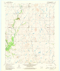
1963 Map of Neodesha
USGS Topo · Published 1980About this map
Neodesha and the surrounding river bottomlands define this portion of northeastern Oklahoma in the early 1960s. The landscape is characterized by the winding path of the Verdigris River and its expansive Guinn Bottom, flanked by the prominent Osage Mound to the southwest. This era shows a rural infrastructure heavily reliant on rail, with the Missouri Pacific and Missouri-Kansas-Texas lines traversing the terrain.
Find a feature on this map
19 named features on this map. Tap any name to fly to it.
Don’t see what you’re looking for? This feature index may not catch every label — zoom into the map to look around manually.
Map Details
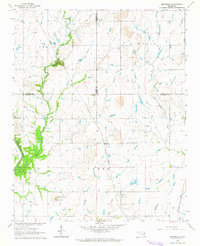
Editions of this 1963 Neodesha Map
2 editions found
Other maps of this area

1896 · Okmulgee
USGS Topo · 1:125,000

1896 · Pryor
USGS Topo · 1:125,000

1900 · Okmulgee
USGS Topo · 1:125,000

1901 · Muscogee
USGS Topo · 1:125,000

1901 · Claremore
USGS Topo · 1:125,000

1901 · Pryor
USGS Topo · 1:125,000

1905 · Muscogee
USGS Topo · 1:125,000

1914 · Claremore
USGS Topo · 1:125,000

1916 · Claremore
USGS Topo · 1:125,000

1946 · Fort Smith
USGS Topo · 1:250,000