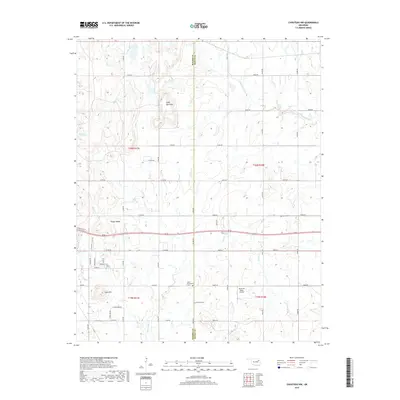
2019 Map of Chouteau NW
USGS Topo · Published 2019About this map
The borderlands of Rogers and Mayes Counties are defined by a landscape of small ridges and creek valleys, where agricultural heritage is anchored by several distinct community burial grounds. Significant local markers include the Amish Cem, Eden Mennonite Cem, Brethren Cem, and Highland Cem, reflecting the diverse denominational roots of the rural families settled along the county line. The terrain rises to prominent elevations at Scaly Bark Mtn, Timber Ridge, and Inola Hill, providing a vertical contrast to the winding paths of Chouteau Creek and Inola Cr. Transport and utility are centered around rural section roads and the presence of Buzzards Roost Airport, which serves this pocket of Oklahoma as a local aviation landmark.
Find a feature on this map
54 named features on this map. Tap any name to fly to it.
Don’t see what you’re looking for? This feature index may not catch every label — zoom into the map to look around manually.
Map Details
Editions of this 2019 Chouteau NW Map
This is the sole edition of this map. No revisions or reprints were ever made.
Other maps of this area

1896 · Pryor
USGS Topo · 1:125,000

1901 · Claremore
USGS Topo · 1:125,000

1901 · Pryor
USGS Topo · 1:125,000

1914 · Claremore
USGS Topo · 1:125,000

1916 · Claremore
USGS Topo · 1:125,000

1954 · Tulsa
USGS Topo · 1:250,000

1958 · Tulsa
USGS Topo · 1:250,000

1963 · Tulsa
USGS Topo · 1:250,000
1963 · Neodesha
USGS Topo · 1:24,000
1963 · Claremore
USGS Topo · 1:24,000