
1918 Map of Chowchilla
USGS Topo · Published 1918About this map
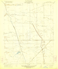
The Chowchilla River and Ash Creek define the northern landscape of this agricultural region during its early 20th-century development. The map details a transition from river-bottom land to an emerging grid of roads and settlements centered on the Chowchilla townsite. The infrastructure of the era is anchored by the Southern Pacific railroad and the Chowchilla Boulevard, which run parallel through the heart of the territory. This alignment reflects the heavy influence of rail-oriented settlement patterns common in the San Joaquin Valley.
Find a feature on this map
16 named features on this map. Tap any name to fly to it.
Don’t see what you’re looking for? This feature index may not catch every label — zoom into the map to look around manually.
Map Details
Editions of this 1918 Chowchilla Map
This is the sole edition of this map. No revisions or reprints were ever made.
Other maps of this area

1916 · Berenda
USGS Topo · 1:31,680

1918 · Bliss Ranch
USGS Topo · 1:31,680

1918 · Lingard
USGS Topo · 1:31,680

1918 · Berenda
USGS Topo · 1:31,680

1918 · La Grand
USGS Topo · 1:31,680

1919 · Plainsberg
USGS Topo · 1:31,680

1920 · Bonita Ranch
USGS Topo · 1:31,680

1921 · Bonita Ranch
USGS Topo · 1:31,680

1922 · Pozo Farm
USGS Topo · 1:31,680
1922 · Kentucky Well
USGS Topo · 1:31,680