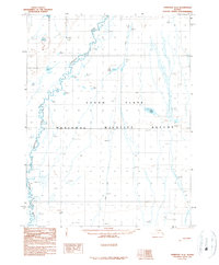
1990 Map of Christian A-3
USGS Topo · Published 1990About this map
The Yukon Flats dominate this interior Alaskan landscape, characterized by a complex network of wetlands and meandering waterways within the National Wildlife Refuge. The Christian River snakes through the western portion of the quadrangle, exhibiting the extreme sinuosity typical of the region's low-relief drainage systems. This 1990 edition, compiled from photography taken in the late 1970s and mid-1980s, captures the seasonal nature of Arctic travel via a marked Winter Trail that cuts north-south across the flats. While most of the terrain is a mosaic of unnamed ponds and marshes, specific landmarks like White Lake and Joint Lake provide essential navigation points in an otherwise shifting environment of silt and spruce.
Find a feature on this map
6 named features on this map. Tap any name to fly to it.
Don’t see what you’re looking for? This feature index may not catch every label — zoom into the map to look around manually.
Map Details
Editions of this 1990 Christian A-3 Map
This is the sole edition of this map. No revisions or reprints were ever made.
Other maps of this area

1951 · Fort Yukon
USGS Topo · 1:250,000

1951 · Christian
USGS Topo · 1:250,000

1955 · Fort Yukon D-2
USGS Topo · 1:63,360

1955 · Fort Yukon D-3
USGS Topo · 1:63,360

1955 · Fort Yukon D-4
USGS Topo · 1:63,360

1956 · Christian
USGS Topo · 1:250,000

1956 · Fort Yukon
USGS Topo · 1:250,000
1956 · Fort Yukon D-3
USGS Topo · 1:63,360
1956 · Fort Yukon D-4
USGS Topo · 1:63,360
1990 · Christian B-3
USGS Topo · 1:63,360