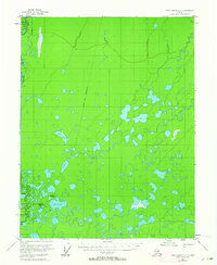
1956 Map of Fort Yukon D-3
USGS Topo · Published 1964About this map
Venetie Indian Reservation lands dominate this mid-century survey, revealing a landscape defined by the winding course of the Christian River and a dense network of subarctic wetlands. The interior terrain is marked by isolated settlements like Alexanders Village, which is situated near the riverbanks and the rise of Shotuih Hill. This area, captured before extensive modern development, highlights the traditional importance of seasonal routes, specifically the Winter Trail that cuts north-south across the muskeg and tundra. Large water bodies such as Shovun Lake, Tivehvun Lake, and Gilbert Lake characterize the drainage patterns of the northern Yukon Flats, where the absence of established permanent roads underscores the reliance on river systems and winter-only paths for movement between remote outposts.
Find a feature on this map
12 named features on this map. Tap any name to fly to it.
Don’t see what you’re looking for? This feature index may not catch every label — zoom into the map to look around manually.
Map Details
Editions of this 1956 Fort Yukon D-3 Map
2 editions found
Other maps of this area

1951 · Fort Yukon
USGS Topo · 1:250,000

1951 · Christian
USGS Topo · 1:250,000

1952 · Fort Yukon C-2
USGS Topo · 1:63,360

1952 · Fort Yukon C-3
USGS Topo · 1:63,360

1952 · Fort Yukon C-4
USGS Topo · 1:63,360

1955 · Fort Yukon D-2
USGS Topo · 1:63,360

1955 · Fort Yukon D-3
USGS Topo · 1:63,360

1955 · Fort Yukon D-4
USGS Topo · 1:63,360

1955 · Fort Yukon C-3
USGS Topo · 1:63,360

1956 · Christian
USGS Topo · 1:250,000