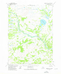
1973 Map of Christian D-1
USGS Topo · Published 1976About this map
Koness River meanders sharply across this Arctic landscape, defining the hydrology of a region where water and marsh dominate the lowlands. This 1973 survey, based on aerial photography from the previous year, captures the intricate network of swamps and seasonal drainages characteristic of the Yukon-Koyukuk interior. A solitary Cabin situated along a northern bend of the river serves as the only evidence of human habitation or shelter in the immediate vicinity, illustrating the extreme isolation of the territory at this time. To the east, Big Fish Lake stands as a prominent geographic landmark amidst the saturated terrain, while Vanticlese Creek feeds into the main river system from the west. The map provides a detailed record of the natural landforms before modern environmental changes, focusing on the complex topography of the river's floodplains.
Find a feature on this map
4 named features on this map. Tap any name to fly to it.
Don’t see what you’re looking for? This feature index may not catch every label — zoom into the map to look around manually.
Map Details
Editions of this 1973 Christian D-1 Map
This is the sole edition of this map. No revisions or reprints were ever made.
Other maps of this area

1951 · Coleen
USGS Topo · 1:250,000

1951 · Christian
USGS Topo · 1:250,000

1951 · Arctic
USGS Topo · 1:250,000

1951 · Table Mountain
USGS Topo · 1:250,000

1956 · Table Mountain
USGS Topo · 1:250,000

1956 · Coleen
USGS Topo · 1:250,000

1956 · Arctic
USGS Topo · 1:250,000

1956 · Christian
USGS Topo · 1:250,000

1964 · Table Mountain
USGS Topo · 1:250,000
1972 · Arctic A-1
USGS Topo · 1:63,360