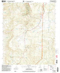
2004 Map of Chrysotile
USGS Topo · Published 2007About this map
Chrysotile sits as a primary point of interest in this high-elevation interior landscape, positioned along the banks of Ash Creek. The area is defined by a network of water management features and mineral extraction sites, including a Mine and various Prospects that indicate a legacy of geological exploration. The terrain is dominated by the massive heights of Timber Camp Mountain and Spring Mountain, while the human presence is marked by the Timber Camp settlement and the Tucker Place further south. Modern infrastructure is evident in the inclusion of an Airstrip near Jackson Butte and an Electronic Site situated on high ground. The map details the boundary between the Tonto National Forest and the San Carlos Reservation, showing how natural features like Sycamore Creek and Onega Creek cut through the complex topography of Bronson Canyon.
Find a feature on this map
57 named features on this map. Tap any name to fly to it.
Don’t see what you’re looking for? This feature index may not catch every label — zoom into the map to look around manually.
Map Details
Editions of this 2004 Chrysotile Map
This is the sole edition of this map. No revisions or reprints were ever made.
Other maps of this area

1922 · Chrysotile
USGS Topo · 1:125,000

1946 · Blue House Mtn
USGS Topo · 1:62,500

1951 · Blue House Mtn
USGS Topo · 1:62,500

1954 · Mesa
USGS Topo · 1:250,000

1957 · Mesa
USGS Topo · 1:250,000

1958 · Mesa
USGS Topo · 1:250,000

1960 · Mesa
USGS Topo · 1:250,000

1964 · Mesa
USGS Topo · 1:250,000

1966 · Brushy Canyon
USGS Topo · 1:24,000

1966 · Cassadore Spring
USGS Topo · 1:24,000