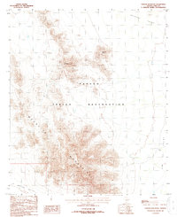
1988 Map of Chupan Mountain
USGS Topo · Published 1988About this map
Papago Indian Reservation lands dominate this 1988 provisional survey, capturing a landscape defined by sharp elevation shifts and traditional water sources. The Mesquite Mountains and Chupan Mountain form a central topographic spine, dividing the terrain between the Quijotoa Valley to the north and Kom Valley to the southeast. This map reflects a period of limited revision, based on 1982 aerial photography and 1985 field checks, documenting the desert floor and its sparse but vital improvements.
Find a feature on this map
10 named features on this map. Tap any name to fly to it.
Don’t see what you’re looking for? This feature index may not catch every label — zoom into the map to look around manually.
Map Details
Editions of this 1988 Chupan Mountain Map
This is the sole edition of this map. No revisions or reprints were ever made.
Other maps of this area

1953 · Ajo
USGS Topo · 1:250,000

1954 · Sonoyta
USGS Topo · 1:250,000

1957 · Ajo
USGS Topo · 1:250,000

1958 · Ajo
USGS Topo · 1:250,000

1962 · Ajo
USGS Topo · 1:250,000

1963 · Ajo
USGS Topo · 1:250,000

1963 · Kom Vo
USGS Topo · 1:62,500

1963 · Mt. Ajo
USGS Topo · 1:62,500

1963 · Pisinimo
USGS Topo · 1:62,500

1963 · Lukeville
USGS Topo · 1:250,000