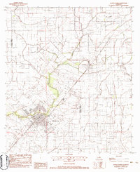
1983 Map of Church Point
USGS Topo · Published 1983About this map
Bayou Plaquemine Brule winds through this region of Acadia and St. Landry parishes, defining the landscape around the primary settlement of Church Point. In the early 1980s, this area reflects a classic Acadiana blend of rural bayou country and active energy extraction, evidenced by the Church Point Oil and Gas Field and Lewisburg Oil and Gas Field. The town itself is a hub of community life, featuring a Jr High Sch, High Sch, and the Our Mother of Peace Sch near the town's center. Further north, the smaller community of Lewisburg sits along the Missouri Pacific rail line, which served as a vital transport artery for the region's agricultural and industrial output. Genealogists will find interest in localized landmarks such as the Baptist Cem and McBride Cem, which anchor the history of longtime parish residents to the land.
Find a feature on this map
25 named features on this map. Tap any name to fly to it.
Don’t see what you’re looking for? This feature index may not catch every label — zoom into the map to look around manually.
Map Details
Editions of this 1983 Church Point Map
This is the sole edition of this map. No revisions or reprints were ever made.
Other maps of this area

1935 · Branch
USGS Topo · 1:31,680

1939 · Opelousas
USGS Topo · 1:62,500

1947 · Branch
USGS Topo · 1:31,680

1947 · Chataignier
USGS Topo · 1:31,680

1947 · Pitreville
USGS Topo · 1:31,680

1952 · Lake Charles
USGS Topo · 1:250,000

1954 · Lake Charles
USGS Topo · 1:250,000

1956 · Opelousas
USGS Topo · 1:62,500

1957 · Opelousas
USGS Topo · 1:62,500

1957 · Carencro
USGS Topo · 1:62,500