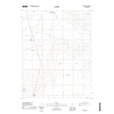
2020 Map of Church Rock
USGS Topo · Published 2020About this map
Church Rock and other monolithic formations stand as central landmarks in this high-desert landscape within Dry Valley. The terrain is defined by a series of dramatic geographic features including Sugar Loaf Rock, George Rock, and the prominent Peters Point Ridge. This 2020 survey illustrates the complex drainage systems of the region, where East Canyon Wash, Hatch Wash, and Peters Wash converge. The mapping of Co Rd 180 and Co Rd 105 shows the modern road network providing access to remote locations like Bucks Flat and Deerneck Mesa. These labels reflect a history of local naming tied to the cattle ranching and geological character of San Juan County, from the narrow passage at The Gap to the deep incisions of Big Canyon and Bridge Canyon.
Find a feature on this map
30 named features on this map. Tap any name to fly to it.
Don’t see what you’re looking for? This feature index may not catch every label — zoom into the map to look around manually.
Map Details
Editions of this 2020 Church Rock Map
This is the sole edition of this map. No revisions or reprints were ever made.
Other maps of this area

1885 · La Sal
USGS Topo · 1:250,000

1886 · Abajo
USGS Topo · 1:250,000

1892 · Abajo
USGS Topo · 1:250,000

1893 · Abajo
USGS Topo · 1:250,000

1954 · Mt Peale 3 NW
USGS Topo · 1:24,000

1954 · Mt Peale 4 NW
USGS Topo · 1:24,000

1954 · Mt Peale 3 SW
USGS Topo · 1:24,000

1954 · Mt Peale 3 NE
USGS Topo · 1:24,000

1954 · Mt Peale 3 SE
USGS Topo · 1:24,000

1954 · Mt Peale 4 SW
USGS Topo · 1:24,000