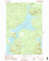
1989 Map of Churchill Lake
USGS Topo · Published 1989About this map
Churchill Depot stands at the northern head of the Allagash Wilderness State Waterway, a critical nexus for forestry and water management in this remote section of Piscataquis County. This 1989 survey documents the infrastructure of the North Maine Woods just before the turn of the 21st century, centered on the expansive waters of Churchill Lake and its connection to Heron Lake via the Concrete and Wood Dam. The landscape is defined by the flow of the Allagash R and the strategic placement of remote outposts like the Zeigler Campsite and Little Eagle Campsite. Further south, the map details the narrow crossing at Johns Bridge, which separates the main lake from the waters of Round Pond and the northern reaches of Eagle Lake. This document provides a clear look at the township boundaries and logging roads that dictate movement through the dense woodlands surrounding Soper Mountain.
Find a feature on this map
39 named features on this map. Tap any name to fly to it.
Don’t see what you’re looking for? This feature index may not catch every label — zoom into the map to look around manually.
Map Details
Editions of this 1989 Churchill Lake Map
2 editions found
Other maps of this area

1932 · Umsaskis Lake
USGS Topo · 1:48,000

1932 · Musquacook Lakes
USGS Topo · 1:48,000

1935 · Umsaskis Lake
USGS Topo · 1:62,500

1935 · Musquacook Lakes
USGS Topo · 1:62,500

1954 · Spider Lake
USGS Topo · 1:62,500

1954 · Churchill Lake
USGS Topo · 1:62,500

1954 · Presque Isle
USGS Topo · 1:250,000

1958 · Presque Isle
USGS Topo · 1:250,000

1960 · Presque Isle
USGS Topo · 1:250,000

1961 · Spider Lake
USGS Topo · 1:62,500