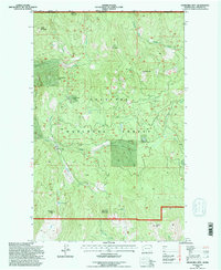
1992 Map of Churchill Mtn
USGS Topo · Published 1996About this map
Mining history and high-altitude terrain dominate this 1990s look at the northern reaches of the Colville National Forest along the Canadian border. The area is defined by a series of significant mining sites tucked into the drainage basins, including the Churchill Mine and the Easter Sunday Mine, which sits just above Easter Sunday Lake. The network of forestry roads and trails provides access to these remote industrial relics and several named peaks such as Billy Goat Mountain and Churchill Mtn.
Find a feature on this map
34 named features on this map. Tap any name to fly to it.
Don’t see what you’re looking for? This feature index may not catch every label — zoom into the map to look around manually.
Map Details
Editions of this 1992 Churchill Mtn Map
This is the sole edition of this map. No revisions or reprints were ever made.
Other maps of this area

1929 · Colville
USGS Topo · 1:125,000

1933 · Colville
USGS Topo · 1:125,000

1936 · Marcus
USGS Topo · 1:96,000

1942 · Marcus
USGS Topo · 1:125,000

1948 · Orient
USGS Topo · 1:62,500

1951 · Orient
USGS Topo · 1:62,500

1954 · Okanogan
USGS Topo · 1:250,000

1958 · Okanogan
USGS Topo · 1:250,000

1958 · Sandpoint
USGS Topo · 1:250,000

1963 · Sandpoint
USGS Topo · 1:250,000