
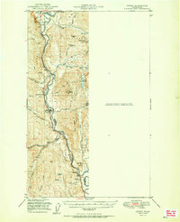
1951 Map of Orient
USGS Topo · Published 1951About this map
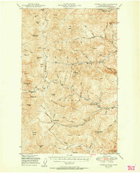
The Kettle River defines the rugged border between Ferry and Stevens counties in this early 1950s study of the northern Washington wilderness. The Great Northern railroad tracks parallel the river's winding path, connecting small mountain settlements like Orient, Barstow, and Dulwich. Mining and forestry are the primary footprints of industry here, evidenced by the Talisman Mine and the Kettle River Mines, as well as the presence of the Orient Ranger Station. Higher elevations such as First Thought Mtn and Summit Mtn tower over numerous mountain drainages like Deep Creek and Toulou Creek. Local civic life is captured in small details, from the Barstow Sch near the southern boundary to the Cem located near the international border at Laurier.
Find a feature on this map
39 named features on this map. Tap any name to fly to it.
Don’t see what you’re looking for? This feature index may not catch every label — zoom into the map to look around manually.
Map Details
Editions of this 1951 Orient Map
2 editions found
Other maps of this area

1929 · Colville
USGS Topo · 1:125,000

1933 · Colville
USGS Topo · 1:125,000

1936 · Marcus
USGS Topo · 1:96,000

1942 · Marcus
USGS Topo · 1:125,000
1948 · Sherman Peak
USGS Topo · 1:62,500

1948 · Kettle Falls
USGS Topo · 1:62,500

1948 · Orient
USGS Topo · 1:62,500
1948 · Togo Mountain
USGS Topo · 1:62,500
1951 · Togo Mountain
USGS Topo · 1:62,500
1951 · Sherman Peak
USGS Topo · 1:62,500