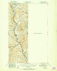
1951 Map of Orient
USGS Topo · Published 1951About this map
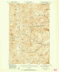
The Kettle River valley serves as the central corridor for commerce and transport in this 1951 survey, winding south through the Colville National Forest. The Great Northern railroad tracks parallel the river, connecting a string of small settlements from the international boundary at Laurier down through Orient and Dulwich to Barstow. This landscape is shaped by the extraction and timber industries of the early-to-mid 20th century, evidenced by the Talisman Mine in the north and the Kettle River Mine (Aban'd) near Summit Mtn. The rugged mountain terrain includes landmarks like First Thought Mtn and McKinley Mtn, while local civic life is anchored by the Barstow Sch and the Orient Ranger Sta. This map reveals the specific intersection of mountain topography and the rail-dependent economy before the expansion of modern highway systems.
Find a feature on this map
46 named features on this map. Tap any name to fly to it.
Don’t see what you’re looking for? This feature index may not catch every label — zoom into the map to look around manually.
Map Details
Editions of this 1951 Orient Map
2 editions found

Other maps of this area

1929 · Colville
USGS Topo · 1:125,000

1933 · Colville
USGS Topo · 1:125,000

1936 · Marcus
USGS Topo · 1:96,000

1942 · Marcus
USGS Topo · 1:125,000
1948 · Sherman Peak
USGS Topo · 1:62,500

1948 · Kettle Falls
USGS Topo · 1:62,500

1948 · Orient
USGS Topo · 1:62,500
1948 · Togo Mountain
USGS Topo · 1:62,500
1951 · Togo Mountain
USGS Topo · 1:62,500
1951 · Sherman Peak
USGS Topo · 1:62,500