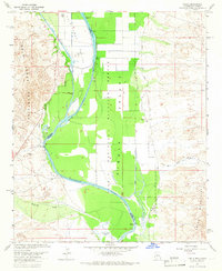
1965 Map of Cibola
USGS Topo · Published 1966About this map
The Colorado River serves as the focal point for this mid-1960s survey of the border region between Arizona and California. Centered on the community of Cibola, the landscape is defined by the expansive Cibola National Wildlife Refuge, where the river's path is flanked by intricate water management features like the Palo Verde Canal and Drain. The terrain transitions from the marshy lowlands of Three Finger Lake and Davis Lake to the rising elevations of the Palo Verde Mountains in the west and the Trigo Mountains in the east.
Find a feature on this map
21 named features on this map. Tap any name to fly to it.
Don’t see what you’re looking for? This feature index may not catch every label — zoom into the map to look around manually.
Map Details
Editions of this 1965 Cibola Map
3 editions found
Other maps of this area

1942 · Blythe
USGS Topo · 1:250,000

1945 · Cibola
USGS Topo · 1:62,500

1945 · Picacho
USGS Topo · 1:62,500

1951 · Picacho
USGS Topo · 1:62,500

1951 · Cibola
USGS Topo · 1:62,500

1952 · Mule Wash
USGS Topo · 1:24,000

1952 · Palo Verde
USGS Topo · 1:24,000

1953 · Palo Verde Mountains
USGS Topo · 1:62,500

1953 · Quartz Peak
USGS Topo · 1:62,500

1954 · Salton Sea
USGS Topo · 1:250,000