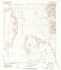
1969 Map of Cienega School
USGS Topo · Published 1973About this map
Crow Flats and the Alkali Lakes dominate this arid borderlands landscape, where New Mexico and Texas meet. The survey reveals a sparse settlement pattern tied to water sources and ranching, evidenced by the Akers Place Windmill and the Lewis Ranch. This remote area, straddling the line between Otero County and Hudspeth County, features the rising peaks of the Brokeoff Mountains to the east. Local life centers on small landmarks such as the Cienega Sch and Cienega Cem, which provide essential clues for genealogists tracing family histories in this desert environment. Significant topographic features like Humphrey Canyon and its smaller counterpart, Little Humphrey Canyon, cut through the eastern uplands, while a simple Jeep Trail provides one of the few named routes across the flats.
Find a feature on this map
15 named features on this map. Tap any name to fly to it.
Don’t see what you’re looking for? This feature index may not catch every label — zoom into the map to look around manually.
Map Details
Editions of this 1969 Cienega School Map
This is the sole edition of this map. No revisions or reprints were ever made.
Other maps of this area

1933 · Guadalupe Peak
USGS Topo · 1:48,000

1935 · El Paso Gap
USGS Topo · 1:62,500

1936 · El Paso Gap
USGS Topo · 1:48,000

1940 · El Paso Gap
USGS Topo · 1:62,500

1940 · Guadalupe Peak
USGS Topo · 1:62,500

1951 · Dell City
USGS Topo · 1:62,500

1954 · Carlsbad
USGS Topo · 1:250,000

1954 · Van Horn
USGS Topo · 1:250,000

1958 · Van Horn
USGS Topo · 1:250,000

1958 · Carlsbad
USGS Topo · 1:250,000