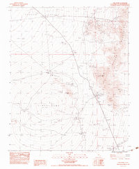
1983 Map of Cima Dome
USGS Topo · Published 1983About this map
Cima Dome rises as the central topographic feature of this high desert landscape in the early 1980s, flanked by the Ivanpah Mountains to the east. The area is defined by a legacy of hard-rock mining, evidenced by the concentration of workings near Teutonia Peak and the northeastern slopes. Names like Standard Mine No 2, Evening Star Mine, and the Johnny Shaft trace a history of prospecting for copper and other minerals in these arid reaches. Water sources were critical for both mining operations and ranching, as seen in the presence of Kessler Spring, Deer Spring, and White Rock Spring. While the desert is crisscrossed by many miles of Sand Wash, human activity is anchored to the landscape at Valley View Ranch and a series of corrals. The map also records the modern infrastructure of the era, including the 3-steel twr trans lines cutting across the southeastern corner.
Find a feature on this map
27 named features on this map. Tap any name to fly to it.
Don’t see what you’re looking for? This feature index may not catch every label — zoom into the map to look around manually.
Map Details
Editions of this 1983 Cima Dome Map
2 editions found
Other maps of this area

1910 · Ivanpah
USGS Topo · 1:250,000

1912 · Ivanpah
USGS Topo · 1:250,000

1942 · Ivanpah
USGS Topo · 1:250,000

1947 · Kingman
USGS Topo · 1:250,000

1948 · Kingman
USGS Topo · 1:250,000

1954 · Kingman
USGS Topo · 1:250,000

1955 · Kingman
USGS Topo · 1:250,000

1955 · Mescal Range
USGS Topo · 1:62,500

1955 · Mid Hills
USGS Topo · 1:62,500

1955 · Kelso
USGS Topo · 1:62,500