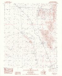
1983 Map of Cima Dome
USGS Topo · Published 1984About this map
Cima Dome rises as the central geometric focus of this high desert landscape, surrounded by a complex network of 20th-century mining operations and remote cattle ranching infrastructure. The concentration of mineral extraction is most evident in the northeast, where the Standard Mine No 2, Evening Star Mine, and Copper King Mine sit within the drainage of Shadow Valley. To the south, Teutonia Peak watches over the Teutonia Mine, while the presence of several Corrals and a Fence Line near Valley View Ranch indicates the continued use of this arid terrain for grazing. Reliable water sources, critical for both mining and livestock, are documented at Kessler Spring, White Rock Spring, and Deer Spring. The terrain transitions from the broad alluvial fans of the dome into the steep, jagged ridges of the Ivanpah Mountains to the east.
Find a feature on this map
22 named features on this map. Tap any name to fly to it.
Don’t see what you’re looking for? This feature index may not catch every label — zoom into the map to look around manually.
Map Details
Editions of this 1983 Cima Dome Map
2 editions found
Other maps of this area

1910 · Ivanpah
USGS Topo · 1:250,000

1912 · Ivanpah
USGS Topo · 1:250,000

1942 · Ivanpah
USGS Topo · 1:250,000

1947 · Kingman
USGS Topo · 1:250,000

1948 · Kingman
USGS Topo · 1:250,000

1954 · Kingman
USGS Topo · 1:250,000

1955 · Kingman
USGS Topo · 1:250,000

1955 · Mescal Range
USGS Topo · 1:62,500

1955 · Mid Hills
USGS Topo · 1:62,500

1955 · Kelso
USGS Topo · 1:62,500