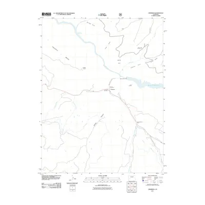
2011 Map of Cimarron
USGS Topo · Published 2011About this map
The settlement of Cimarron sits at the heart of this Montrose County landscape, where the Gunnison River and the Cimarron River converge amidst a network of high mesas and deep gulches. Modern infrastructure, represented by the Morrow Point Dam and the Crystal Reservoir, stands alongside legacies of early development like the Cimarron Ditch and Collier Ditch. The presence of the District Number 9 School and the Cimarron Post Office marks the community center, while the Goat Hill Mine reflects the area's historical extraction activity. This survey captures a region defined by its water management and agricultural irrigation, with prominent terrain features such as Poverty Mesa and Diehl Point overlooking the river valleys. Recreation is also central to the area's character, evidenced by the Mesa Creek Campground and Cimarron Campground near the banks of the Morrow Point Reservoir.
Find a feature on this map
32 named features on this map. Tap any name to fly to it.
Don’t see what you’re looking for? This feature index may not catch every label — zoom into the map to look around manually.
Map Details
Editions of this 2011 Cimarron Map
This is the sole edition of this map. No revisions or reprints were ever made.
Other maps of this area

1908 · Uncompahgre
USGS Topo · 1:125,000

1909 · Montrose
USGS Topo · 1:125,000

1911 · Uncompahgre
USGS Topo · 1:125,000

1911 · Montrose
USGS Topo · 1:125,000

1956 · Curecanti Needle
USGS Topo · 1:24,000

1956 · Cimarron
USGS Topo · 1:24,000

1956 · Montrose
USGS Topo · 1:250,000

1957 · Cathedral Peak
USGS Topo · 1:24,000

1957 · X Lazy F Ranch
USGS Topo · 1:24,000

1957 · Cerro Summit
USGS Topo · 1:24,000