
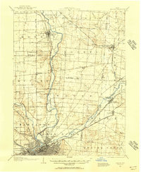
1957 Map of Cincinnati
USGS Topo · Published 1957About this map
The Ohio River corridor serves as the anchor for this mid-century regional survey, highlighting the industrial and urban density of Cincinnati, Covington, and Newport just after the post-war expansion. This survey captures a sprawling network of major rail lines, including the Pennsylvania RR and the Baltimore and Ohio RR, which knit together significant manufacturing hubs like Dayton, Hamilton, and Middletown.
Find a feature on this map
95 named features on this map. Tap any name to fly to it.
Don’t see what you’re looking for? This feature index may not catch every label — zoom into the map to look around manually.
Map Details
Editions of this 1957 Cincinnati Map
This is the sole edition of this map. No revisions or reprints were ever made.
Other maps of this area

1898 · East Cincinnati
USGS Topo · 1:62,500

1904 · Springfield
USGS Topo · 1:62,500
1904 · Dayton
USGS Topo · 1:62,500

1904 · Mason
USGS Topo · 1:62,500

1905 · Brookville
USGS Topo · 1:62,500
1906 · Dayton
USGS Topo · 1:62,500

1906 · Mason
USGS Topo · 1:62,500

1906 · Springfield
USGS Topo · 1:62,500

1907 · Blanchester
USGS Topo · 1:62,500

1908 · Miamisburg
USGS Topo · 1:62,500