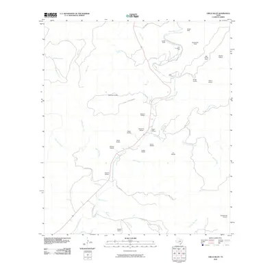
2010 Map of Circle Bluff
USGS Topo · Published 2010About this map
East Frio River dominates the central corridor of this Real County landscape, carving through a complex network of canyons and hollows characteristic of the Texas Hill Country. The 2010 survey highlights the Butt Foundation Camp and the Perry Ranch along the river's upper reaches, where steep vertical features like Circle Bluff and Brown Bluff define the local topography. Away from the water, the terrain is fragmented by numerous named draws and hollows such as Pole Cave Hollow and Sycamore Hollow, many associated with long-standing local families. Genealogists and historians will find the Cypress Creek Cemetery located near the confluence of Cypress Creek, marking a point of community identity in this ranch-heavy region. The map also records early water sources essential to the area's development, including Panther Spring and Big Spring.
Find a feature on this map
51 named features on this map. Tap any name to fly to it.
Don’t see what you’re looking for? This feature index may not catch every label — zoom into the map to look around manually.
Map Details
Editions of this 2010 Circle Bluff Map
This is the sole edition of this map. No revisions or reprints were ever made.
Other maps of this area

1954 · San Antonio
USGS Topo · 1:250,000

1956 · Utopia
USGS Topo · 1:62,500

1957 · San Antonio
USGS Topo · 1:250,000

1957 · York Hollow
USGS Topo · 1:62,500

1964 · Hillcrest Ranch
USGS Topo · 1:24,000

1964 · Circle Bluff
USGS Topo · 1:24,000

1964 · Sabinal Canyon
USGS Topo · 1:24,000

1964 · Well Hollow
USGS Topo · 1:24,000
1969 · Vanderpool
USGS Topo · 1:24,000
1969 · Rio Frio
USGS Topo · 1:24,000