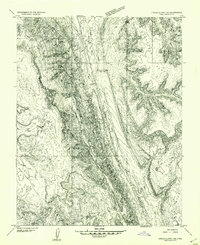
1953 Map of Circle Cliffs 1 NE
USGS Topo · Published 1954About this map
Waterpocket Reef dominates this early 1950s preliminary survey of Garfield County, Utah, where the massive geologic fold of The Monocline creates a stark, north-south spine across the territory. This map documents a high desert landscape defined by its drainage systems and distinct plateaus before the region was extensively mapped for 15-minute quadrangles. To the east, the rising elevations of Tarantula Mesa overlook the carved passages of Spring Canyon, while the western portion is characterized by White Canyon Flat and the remote Onion Flat Seep. The drainage of Hall Creek follows the base of the reef, while the Bitter Creek Divide marks the transition between these prominent desert basins. This sheet provides an immediate look at the land's natural geometry and water sources as recorded by the Geological Survey during its 1953 field mapping season.
Find a feature on this map
10 named features on this map. Tap any name to fly to it.
Don’t see what you’re looking for? This feature index may not catch every label — zoom into the map to look around manually.
Map Details
Editions of this 1953 Circle Cliffs 1 NE Map
This is the sole edition of this map. No revisions or reprints were ever made.
Other maps of this area

1885 · San Rafael
USGS Topo · 1:250,000

1885 · Fish Lake
USGS Topo · 1:250,000

1886 · Escalante
USGS Topo · 1:250,000

1886 · Henry Mountains
USGS Topo · 1:250,000

1892 · Henry Mountains
USGS Topo · 1:250,000

1896 · Fish Lake
USGS Topo · 1:250,000

1952 · Notom 4 SE
USGS Topo · 1:24,000

1952 · Notom 4 SW
USGS Topo · 1:24,000

1952 · Notom
USGS Topo · 1:62,500

1953 · Mt Pennell
USGS Topo · 1:62,500