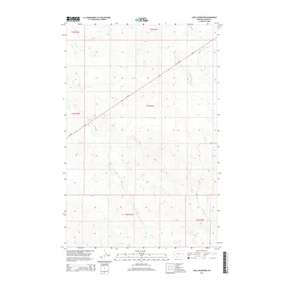
2014 Map of Circle Reservoir
USGS Topo · Published 2014About this map
Circle Reservoir serves as a focal point in this portion of Dawson County, where the high plains landscape is defined by a dendritic network of intermittent drainage. The area's hydrology is primarily shaped by Sullivan Cr and Alkali Cr, which carve through the terrain alongside the various branches of Pasture Cr. Transportation across this expansive ranching country is anchored by MT-200, which cuts diagonally across the northern townships, and Road 412 providing access to the eastern sections. This 2014 survey illustrates the persistence of the Public Land Survey System, showing the clearly defined township and range boundaries such as t21n r51e that continue to organize the agricultural and geographic identity of eastern Montana.
Find a feature on this map
14 named features on this map. Tap any name to fly to it.
Don’t see what you’re looking for? This feature index may not catch every label — zoom into the map to look around manually.
Map Details
Editions of this 2014 Circle Reservoir Map
This is the sole edition of this map. No revisions or reprints were ever made.
Other maps of this area

1954 · Glendive
USGS Topo · 1:250,000

1957 · Glendive
USGS Topo · 1:250,000

1958 · Glendive
USGS Topo · 1:250,000

1982 · Circle
USGS Topo · 1:100,000

1983 · Johnson Reservoir NW
USGS Topo · 1:24,000
1983 · Richey
USGS Topo · 1:24,000

1983 · Buffalo Creek NE
USGS Topo · 1:24,000

1983 · Circle Reservoir
USGS Topo · 1:24,000
1983 · Johnson Reservoir NE
USGS Topo · 1:24,000

1983 · Richey NW
USGS Topo · 1:24,000