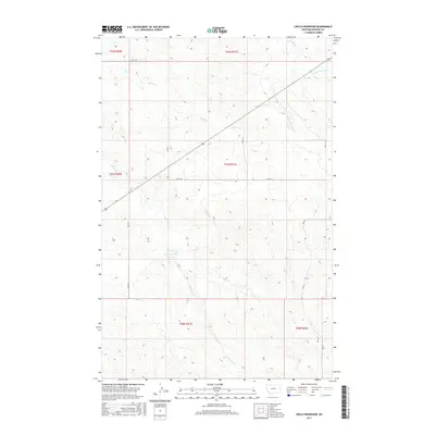
2017 Map of Circle Reservoir
USGS Topo · Published 2017About this map
Circle Reservoir lies at the heart of this Dawson County landscape, serving as a vital catchment in an area defined by its seasonal drainage systems. The terrain is intricately carved by intermittent waterways like Alkali Cr and Sullivan Cr, which flow through the rolling breaks of eastern Montana. This survey illustrates the modern rural infrastructure of the region, where gravel routes such as Rd N 115 and Rd M 13-S follow section lines to connect isolated ranch lands. The drainage pattern of Pasture Cr and its tributaries, including the E Fork Pasture Cr and N Fork Pasture Cr, shows the natural erosion typical of the Missouri Plateau. A few primitive routes, labeled as Field Trl, provide the only access into the more deeply dissected coulees and ridges away from the primary county roads.
Find a feature on this map
16 named features on this map. Tap any name to fly to it.
Don’t see what you’re looking for? This feature index may not catch every label — zoom into the map to look around manually.
Map Details
Editions of this 2017 Circle Reservoir Map
This is the sole edition of this map. No revisions or reprints were ever made.
Other maps of this area

1954 · Glendive
USGS Topo · 1:250,000

1957 · Glendive
USGS Topo · 1:250,000

1958 · Glendive
USGS Topo · 1:250,000

1982 · Circle
USGS Topo · 1:100,000

1983 · Johnson Reservoir NW
USGS Topo · 1:24,000
1983 · Richey
USGS Topo · 1:24,000

1983 · Buffalo Creek NE
USGS Topo · 1:24,000

1983 · Circle Reservoir
USGS Topo · 1:24,000
1983 · Johnson Reservoir NE
USGS Topo · 1:24,000

1983 · Richey NW
USGS Topo · 1:24,000