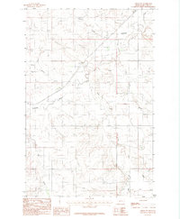
1983 Map of Circle SW
USGS Topo · Published 1983About this map
The Redwater River and its complex network of tributaries define this part of McCone County, Montana. This 1983 manuscript drawing shows a landscape primarily shaped by water and elevation, where seasonal drainages like Antelope Creek, Stony Butte Creek, and Ash Creek carve into the prairie. The presence of Landing Strips suggests the importance of light aircraft for navigating this expansive ranching country, while a lonely Cem label indicates a historic burial site for the area's early homesteading families.
Find a feature on this map
11 named features on this map. Tap any name to fly to it.
Don’t see what you’re looking for? This feature index may not catch every label — zoom into the map to look around manually.
Map Details
Editions of this 1983 Circle SW Map
This is the sole edition of this map. No revisions or reprints were ever made.
Other maps of this area

1954 · Glendive
USGS Topo · 1:250,000

1957 · Glendive
USGS Topo · 1:250,000

1958 · Glendive
USGS Topo · 1:250,000

1965 · Watkins
USGS Topo · 1:24,000

1982 · Circle
USGS Topo · 1:100,000

1983 · Youngquist Mine
USGS Topo · 1:24,000

1983 · Brockway NE
USGS Topo · 1:24,000

1983 · Quick Reservoir
USGS Topo · 1:24,000

1983 · Circle
USGS Topo · 1:24,000
1983 · Brockway
USGS Topo · 1:24,000