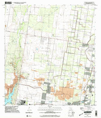
2002 Map of Citrus City
USGS Topo · Published 2003About this map
Citrus City and La Joya anchor a landscape defined by industrial extraction and educational expansion along the Rio Grande valley. While topography was recorded in the 1960s, this 2002 update reveals the extensive reach of the Tabasco Oil and Gas Field and a proliferation of massive Quarry sites that dominate the terrain east of La Joya Lake. The map serves as a detailed record of local ranching heritage, preserving the locations of La Morita Ranch, El Veleno Ranch, and Santa Rita Ranch amidst the shifting industrial footprint.
Find a feature on this map
26 named features on this map. Tap any name to fly to it.
Don’t see what you’re looking for? This feature index may not catch every label — zoom into the map to look around manually.
Map Details
Editions of this 2002 Citrus City Map
This is the sole edition of this map. No revisions or reprints were ever made.
Other maps of this area

1940 · Monte Christo
USGS Topo · 1:62,500

1949 · Mc Allen
USGS Topo · 1:250,000

1954 · McAllen
USGS Topo · 1:250,000

1956 · Garcias
USGS Topo · 1:62,500

1956 · Los Ebanos
USGS Topo · 1:62,500

1957 · Mc Allen
USGS Topo · 1:250,000

1962 · McAllen
USGS Topo · 1:250,000

1963 · Monte Christo
USGS Topo · 1:24,000

1963 · La Joya
USGS Topo · 1:24,000

1963 · Citrus City
USGS Topo · 1:24,000