
1924 Map of Citrus Cove
USGS Topo · Published 1924About this map
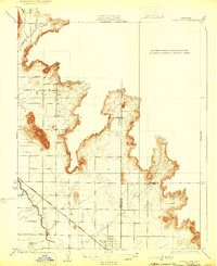
Orange Cove stands as the primary rail hub on this 1924 survey, situated at the junction of the Atchison Topeka and Santa Fe railroad line. The landscape is defined by the sharp transition between the agricultural valley floor and the foothills of the Sierra Nevada. Early infrastructure for the region's citrus industry is visible through the Alta Irrigation District Canal, which traces the contours of the terrain to support local groves. The survey also captures rural community centers such as the Citrus Cove School and the settlement of Mt Olive, located near the base of Granite Hill. A clear boundary line marks the division between Fresno and Tulare counties, bisecting the intricate topography of Hills Valley and the Citrus Cove embayment.
Find a feature on this map
12 named features on this map. Tap any name to fly to it.
Don’t see what you’re looking for? This feature index may not catch every label — zoom into the map to look around manually.
Map Details
Editions of this 1924 Citrus Cove Map
2 editions found
Other maps of this area

1920 · Orangedale School
USGS Topo · 1:24,000

1921 · Squaw Valley
USGS Topo · 1:31,680

1921 · Stokes Mountain
USGS Topo · 1:24,000

1922 · Trimmer
USGS Topo · 1:96,000

1923 · Sultana
USGS Topo · 1:31,680

1923 · Orangedale School
USGS Topo · 1:31,680

1923 · Wahtoke
USGS Topo · 1:31,680

1924 · Reedley
USGS Topo · 1:31,680

1924 · Dinuba
USGS Topo · 1:125,000

1924 · Stokes Mountain
USGS Topo · 1:31,680