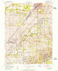
1951 Map of Citrus Heights
USGS Topo · Published 1956About this map
Roseville sits at the northern edge of this 1951 survey, where the Southern Pacific railroad creates a diagonal spine through the expanding suburban landscape of northern Sacramento County. The era's transition from agriculture to residential growth is visible in the network of established roads like Auburn Blvd and Greenback Lane, which connect scattered schools and community hubs. To the south, the American River and the historical land grant boundary of Rio De Los Americanos define the terrain, featuring significant Dredge Tailings along the riverbanks that point to the region's industrial mining legacy.
Find a feature on this map
51 named features on this map. Tap any name to fly to it.
Don’t see what you’re looking for? This feature index may not catch every label — zoom into the map to look around manually.
Map Details
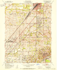
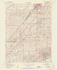
Editions of this 1951 Citrus Heights Map
3 editions found
Other maps of this area

1891 · Sacramento
USGS Topo · 1:125,000

1892 · Sacramento
USGS Topo · 1:125,000

1893 · Sacramento
USGS Topo · 1:125,000

1902 · Fairoaks
USGS Topo · 1:62,500

1908 · Buffalo Creek
USGS Topo · 1:31,680

1910 · Roseville
USGS Topo · 1:31,680

1910 · Pleasant Grove
USGS Topo · 1:31,680

1911 · Brighton
USGS Topo · 1:31,680

1911 · Mills
USGS Topo · 1:31,680

1911 · Arcade
USGS Topo · 1:31,680