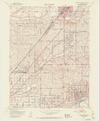
1951 Map of Citrus Heights
USGS Topo · Published 1956About this map
Roseville and its bustling rail yards sit at the northern edge of this 1951 study, where the Southern Pacific railroad cuts a diagonal path toward the expanding suburbs of Citrus Heights and Fair Oaks. The landscape reflects a transition from rural ranching to post-war residential development, featuring a dense network of early neighborhood schools like Sylvan Sch and Mariposa Ave School.
Find a feature on this map
59 named features on this map. Tap any name to fly to it.
Don’t see what you’re looking for? This feature index may not catch every label — zoom into the map to look around manually.
Map Details
Editions of this 1951 Citrus Heights Map
3 editions found
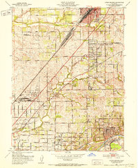
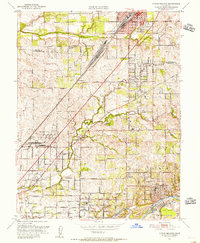
Other maps of this area

1891 · Sacramento
USGS Topo · 1:125,000

1892 · Sacramento
USGS Topo · 1:125,000

1893 · Sacramento
USGS Topo · 1:125,000

1902 · Fairoaks
USGS Topo · 1:62,500

1908 · Buffalo Creek
USGS Topo · 1:31,680

1910 · Roseville
USGS Topo · 1:31,680

1910 · Pleasant Grove
USGS Topo · 1:31,680

1911 · Brighton
USGS Topo · 1:31,680

1911 · Mills
USGS Topo · 1:31,680

1911 · Arcade
USGS Topo · 1:31,680