1975 Map of Citrus Heights
USGS Topo · Published 1977About this map
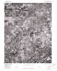
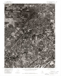
Citrus Heights and its surrounding communities are documented in this mid-1970s orthophotoquad, showing the dense residential growth and suburban expansion north of the American River. This orthophotograph, derived from aerial imagery captured in 1975, reveals the complex network of subdivisions and arterial roads connecting Roseville in the north to the established neighborhoods of Carmichael and Fair Oaks in the south. Unlike traditional topographic maps, this photographic view provides a direct visual of land usage, from the open fields near North Highlands to the tightly packed rooftops and commercial corridors that defined the Sacramento suburban landscape during this era. It captures the region just before the massive digital-age growth of the following decades.
Find a feature on this map
6 named features on this map. Tap any name to fly to it.
Don’t see what you’re looking for? This feature index may not catch every label — zoom into the map to look around manually.
Map Details
Editions of this 1975 Citrus Heights Map
2 editions found
Other maps of this area

1891 · Sacramento
USGS Topo · 1:125,000

1892 · Sacramento
USGS Topo · 1:125,000

1893 · Sacramento
USGS Topo · 1:125,000

1902 · Fairoaks
USGS Topo · 1:62,500

1908 · Buffalo Creek
USGS Topo · 1:31,680

1910 · Roseville
USGS Topo · 1:31,680

1910 · Pleasant Grove
USGS Topo · 1:31,680

1911 · Brighton
USGS Topo · 1:31,680

1911 · Mills
USGS Topo · 1:31,680

1911 · Arcade
USGS Topo · 1:31,680