1975 Map of Citrus Heights
USGS Topo · Published 1978About this map
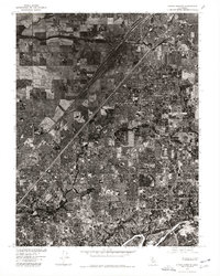
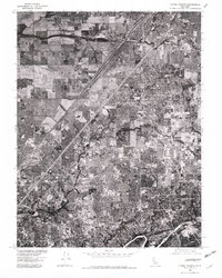
Citrus Heights and the surrounding suburban reaches of Sacramento County are captured in this 1975 orthophotoquad, which uses aerial photography to detail the landscape's mid-decade expansion. The dense residential patterns of Carmichael and Fair Oaks dominate the southeastern portion of the sheet, revealing the intricate street networks and housing developments that defined this era of Northern California growth. In the south, the American River carves a distinctive natural boundary against the encroaching suburban sprawl. The map's photographic nature provides a clear view of the contrast between the established neighborhoods of North Highlands and the more organized grid-work of the central quadrangle, showing how transport corridors and agricultural remnants shaped the region's development during the mid-1970s.
Find a feature on this map
5 named features on this map. Tap any name to fly to it.
Don’t see what you’re looking for? This feature index may not catch every label — zoom into the map to look around manually.
Map Details
Editions of this 1975 Citrus Heights Map
2 editions found
Other maps of this area

1891 · Sacramento
USGS Topo · 1:125,000

1892 · Sacramento
USGS Topo · 1:125,000

1893 · Sacramento
USGS Topo · 1:125,000

1902 · Fairoaks
USGS Topo · 1:62,500

1908 · Buffalo Creek
USGS Topo · 1:31,680

1910 · Roseville
USGS Topo · 1:31,680

1910 · Pleasant Grove
USGS Topo · 1:31,680

1911 · Brighton
USGS Topo · 1:31,680

1911 · Mills
USGS Topo · 1:31,680

1911 · Arcade
USGS Topo · 1:31,680