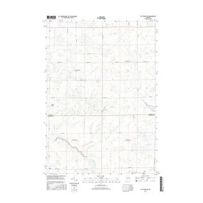
2015 Map of City Point NW
USGS Topo · Published 2015About this map
Pray sits at the southwestern edge of this landscape, marking a clear point of settlement in an area otherwise defined by the complex water systems of central Wisconsin. The boundary between Clark Co and Jackson Co bisects the terrain, which is dominated by the meandering path of the East Fork Black River and its numerous tributaries. Dense wetlands and marshes are prominent, particularly the Ammundson Marsh in the southeast and the smaller Washburn Pond near the center. The presence of Sherwood Lake and topographical features like Brushy Ridge indicate a diverse natural environment where land use is largely dictated by the saturation of the soil. A network of rural roads such as Pray Rd and Ballard Rd provides access through these drainages, connecting the isolated residences and agricultural plots that follow the more stable ground between Hay Meadow Cr and Rock Cr.
Find a feature on this map
35 named features on this map. Tap any name to fly to it.
Don’t see what you’re looking for? This feature index may not catch every label — zoom into the map to look around manually.
Map Details
Editions of this 2015 City Point NW Map
This is the sole edition of this map. No revisions or reprints were ever made.
Other maps of this area

1953 · Neillsville
USGS Topo · 1:62,500

1953 · Eau Claire
USGS Topo · 1:250,000

1954 · Granton
USGS Topo · 1:62,500

1957 · City Point
USGS Topo · 1:48,000

1958 · Eau Claire
USGS Topo · 1:250,000

1958 · Hatfield
USGS Topo · 1:48,000

1964 · Eau Claire
USGS Topo · 1:250,000

1970 · City Point NE
USGS Topo · 1:24,000

1970 · Spaulding
USGS Topo · 1:24,000
1970 · City Point
USGS Topo · 1:24,000