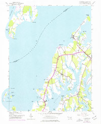
1942 Map of Claiborne
USGS Topo · Published 1976About this map
Eastern Bay divides the landscape of this mid-century Maryland survey, separating the southern tip of Kent Island from the intricate peninsulas of the Talbot County mainland. The eastern shore is defined by deep tidal inlets like Harris Creek, Broad Creek, and Grace Creek, which carved the land into long necks of fertile ground where coastal settlements flourished. Small hubs such as Claiborne and McDaniel are connected by the Baltimore and Eastern line, while local life centered on landmarks like the Wittman Sch, St Johns Ch, and James Ch. Out in the Chesapeake Bay, several islands including Poplar Island, Jefferson Island, and Coaches Island remain clearly delineated before decades of shoreline erosion altered their profiles. The map captures a maritime economy in transition, where ferry landings and cove-side settlements like Sherwood and Bozman relied on both the rail and the water.
Find a feature on this map
51 named features on this map. Tap any name to fly to it.
Don’t see what you’re looking for? This feature index may not catch every label — zoom into the map to look around manually.
Map Details
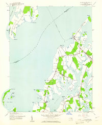
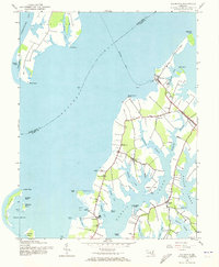
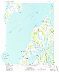
Editions of this 1942 Claiborne Map
4 editions found
Other maps of this area

1892 · Annapolis
USGS Topo · 1:62,500

1893 · Sharps Island
USGS Topo · 1:62,500

1898 · Choptank
USGS Topo · 1:125,000

1904 · St. Michaels
USGS Topo · 1:62,500

1904 · Annapolis
USGS Topo · 1:62,500

1904 · Sharps Island
USGS Topo · 1:62,500

1904 · Oxford
USGS Topo · 1:62,500

1908 · Choptank
USGS Topo · 1:125,000

1942 · Tilghman
USGS Topo · 1:31,680

1942 · Oxford
USGS Topo · 1:31,680