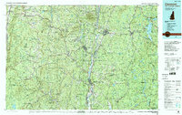
1985 Map of Claremont
USGS Topo · Published 1988About this map
Connecticut River serves as the central artery of this New Hampshire and Vermont borderland, where the industrial heritage of the Sugar River and Black River valleys meets the peaks of the Green Mountains. The urban centers of Claremont and Springfield are detailed alongside smaller rail-oriented hamlets like Gassetts and Proctorsville. The map captures a high density of public lands, including the Calvin Coolidge State Forest and Okemo State Forest, preserving the wooded character of the hills even as recreation expanded around Sunapee Lake.
Find a feature on this map
180 named features on this map. Tap any name to fly to it.
Don’t see what you’re looking for? This feature index may not catch every label — zoom into the map to look around manually.
Map Details
Editions of this 1985 Claremont Map
2 editions found
Other maps of this area

1889 · Wilmington
USGS Topo · 1:62,500

1891 · Wilmington
USGS Topo · 1:62,500

1891 · Brattleboro
USGS Topo · 1:62,500

1891 · Rutland
USGS Topo · 1:62,500

1893 · Wallingford
USGS Topo · 1:62,500

1893 · Brattleboro
USGS Topo · 1:62,500

1893 · Rutland
USGS Topo · 1:62,500

1894 · Londonderry
USGS Topo · 1:62,500

1894 · Pawlet
USGS Topo · 1:62,500

1894 · Equinox
USGS Topo · 1:62,500