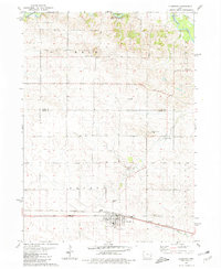
1980 Map of Clarence
USGS Topo · Published 1981About this map
Clarence serves as the primary hub of activity in this eastern Iowa landscape, situated along the prominent Chicago and North Western rail line and the historic Yankee Run route. The surrounding townships of Hale, Oxford, Dayton, and Massillon reveal a late-20th-century rural pattern of dispersed farmsteads and agricultural infrastructure, including a series of community-centric landmarks like Roadside Park and several local quarries.
Find a feature on this map
23 named features on this map. Tap any name to fly to it.
Don’t see what you’re looking for? This feature index may not catch every label — zoom into the map to look around manually.
Map Details
Editions of this 1980 Clarence Map
This is the sole edition of this map. No revisions or reprints were ever made.
Other maps of this area

1889 · Tipton
USGS Topo · 1:62,500

1890 · Tipton
USGS Topo · 1:62,500

1891 · Monticello
USGS Topo · 1:62,500

1891 · Baldwin
USGS Topo · 1:62,500

1892 · Wheatland
USGS Topo · 1:62,500

1894 · Wheatland
USGS Topo · 1:62,500

1900 · Anamosa
USGS Topo · 1:125,000

1901 · Peosta
USGS Topo · 1:125,000

1901 · Rock Island
USGS Topo · 1:125,000

1901 · Stanwood
USGS Topo · 1:125,000