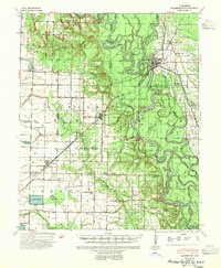
1941 Map of Clarendon
USGS Topo · Published 1951About this map
The White River and Cache River converge at Clarendon, a central hub for river commerce and rail transport in this 1941 edition. This landscape is defined by its complex hydrography, where the main river channels are flanked by countless oxbows and backwaters like Four Mile Bay and Johnson Bay. Historically significant landmarks include the Ramsey Mill Site and the Preston Ferry, which provided critical crossing points for locals moving between Monroe County and Arkansas County.
Find a feature on this map
69 named features on this map. Tap any name to fly to it.
Don’t see what you’re looking for? This feature index may not catch every label — zoom into the map to look around manually.
Map Details
Editions of this 1941 Clarendon Map
2 editions found

Other maps of this area

1935 · Hazen
USGS Topo · 1:62,500

1935 · Clarendon
USGS Topo · 1:62,500

1937 · Stuttgart
USGS Topo · 1:62,500

1939 · Indian Bay
USGS Topo · 1:62,500

1939 · Stuttgart
USGS Topo · 1:62,500

1940 · Holly Grove
USGS Topo · 1:62,500

1940 · Brinkley
USGS Topo · 1:62,500

1941 · Hazen
USGS Topo · 1:62,500

1941 · De Witt
USGS Topo · 1:62,500

1941 · De Valls Bluff
USGS Topo · 1:62,500