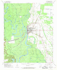
1968 Map of Clarendon
USGS Topo · Published 1970About this map
Clarendon serves as the focal point of this Eastern Arkansas landscape, situated at the confluence where the Cache River meets the winding White River. The town's layout and surrounding agriculture are heavily influenced by the hydraulic patterns of these waterways, evidenced by the extensive Levee system and numerous oxbow lakes such as Big Weidmann Lake and Upper Old River. The St Louis Southwestern railroad cuts diagonally across the terrain, providing a historic transportation artery that bypassed the dense wetlands of the Roc Roe Bayou and Beer Slough. Scattered rural settlements like Keevil and local landmarks including Grove Ch and Shady Grove Cem reflect the area's established social geography. The map illustrates a landscape of precision water management and river-dependent commerce, from the Gaging Station on the riverbank to the various landing strips and substations that supported the mid-century regional economy.
Find a feature on this map
55 named features on this map. Tap any name to fly to it.
Don’t see what you’re looking for? This feature index may not catch every label — zoom into the map to look around manually.
Map Details
Editions of this 1968 Clarendon Map
2 editions found
Other maps of this area

1935 · Clarendon
USGS Topo · 1:62,500

1940 · Holly Grove
USGS Topo · 1:62,500

1940 · Brinkley
USGS Topo · 1:62,500

1941 · De Valls Bluff
USGS Topo · 1:62,500

1941 · Clarendon
USGS Topo · 1:62,500

1948 · Helena
USGS Topo · 1:250,000

1950 · Helena
USGS Topo · 1:250,000

1955 · Helena
USGS Topo · 1:250,000
1957 · Clarendon
USGS Topo · 1:62,500

1957 · Holly Grove
USGS Topo · 1:62,500